- 402 E. Main Street, Buena Vista CO (719.395.8001)
- BV 9:00 am - 6:30 pm Every Day
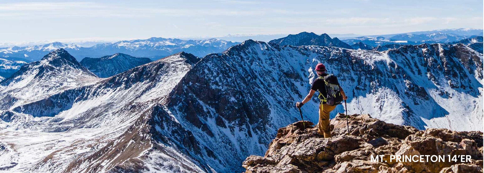
With over 53 mountains exceeding 14,000 feet, Colorado is a renowned “Fourteener” state. Buena Vista in particular is a mountain climber’s paradise, as Chaffee County has the highest concentration of Fourteeners in all of Colorado. All 15 of the Sawatch Range Fourteeners are within an easy distance from downtown Buena Vista, allowing you to lodge in town and enjoy a fresh meal, taste of local beer, or soak in the hot springs after you've summited one of these mountains.
Unless you’re planning to snowshoe, the best months to peak a Fourteener are typically between July and September. If you try to go much before or after those months, you're likely to face heavy snow. Some seasons you’ll be able to climb in late June or early October, as the weather and snowfall varies from year to year. Be prepared to get an early start on your hike. Afternoon thunderstorms are common, so you’ll want to summit before noon, which typically means leaving the trailhead no later than 4:00-5:00 a.m.
You’ll want a relatively small and lightweight dayhiking pack for peak days. Make sure the pack fits well, especially on your hips (so you don’t have all the weight in your shoulders). The size of your pack will be dependent on how many layers and how much gear you want to bring with you.
You’ll want a sturdy hiking boots or cross-trainers. Boots with ankle support can be helpful on rocky and uneven trails that lead to peaks.
Make sure to completely avoid cotton! You’ll want to dress in layers because you’ll typically switch from being cold and hot during your hike, with mornings being chilly, afternoons being warm, and peaks being cold. You usually want to have a base layer short sleeve shirt or tank top, topped by a long sleeve shirt or mid-weight layer. On top of that, you can add a jacket. Always make sure you bring a rain jacket; you never know when you’ll run into one of Colorado’s torrential downpours. On your legs, you could wear nylon hiking pants with zip-off legs (with the pants turning into shorts) or wear leggings and shorts.
Depending on how long your hike is, you should bring around 2-4 liters of water. You could bring a couple full 32 ounce water bottles or fill a bladder in a hydration pack. You could also bring iodine tablets or drops to make stream water safe for drinking.
Pack food and snacks like granola bars, trail mix, beef jerky, gel shots or cliff bar energy blocks. Make sure the food you bring has a good balance of protein and carbohydrates. Foods with high fructose corn syrup will not digest well, and foods with a high sugar content will give you a quick rush of energy but then will make you crash.
At 14,000 feet, the sun is extremely strong, so make sure to grab sun block and lip balm with SPF.
You may have to hike around a bit to reach service, but bringing a phone is important in case you need to contact help.
At least one person in your group should have a first aid kit. You’ll especially want to bring mule skin or Band-Aids for blisters.
For more info about climbing Fourteeners near Buena Vista, visit www.14ers.com for additional route info and updates on trail conditions. Here are some of our favorite Fourteeners to climb:
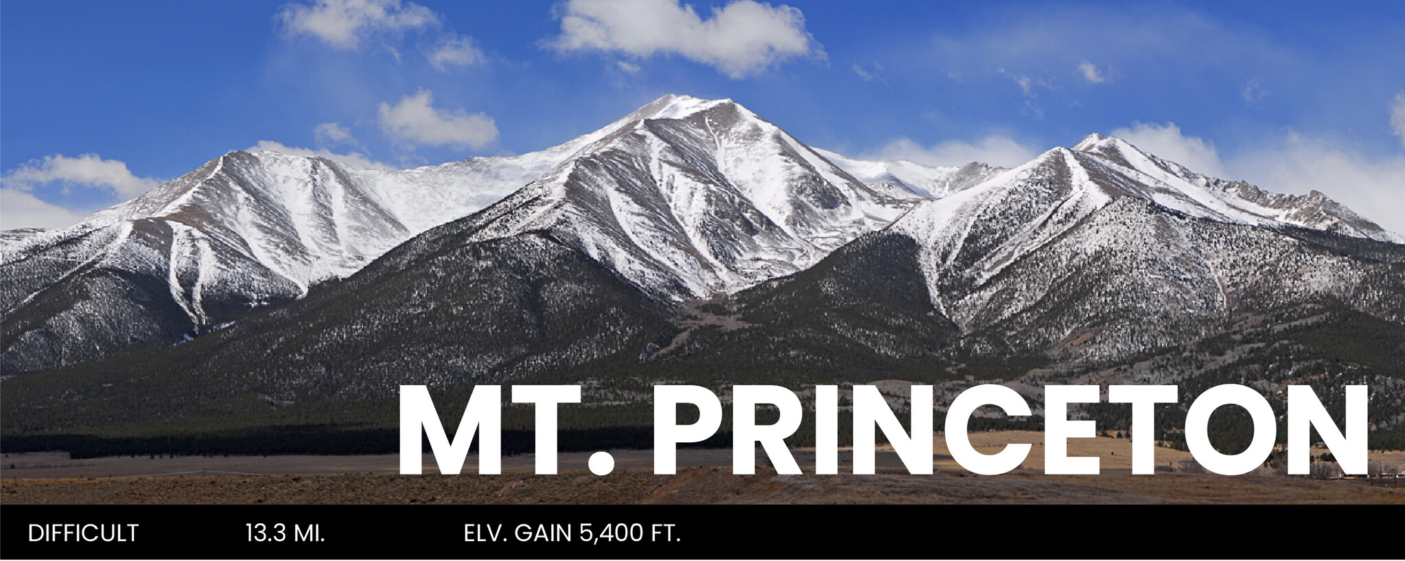
Mt. Princeton is an iconic 14er that towers above Buena Vista. With a road ascending high up its slopes dating back to the mining era, Mt. Princeton offers an easy approach for those with 4WD and high clearance on their vehicle. Those without have a slightly longer hike from the lower trailhead. Regardless of which you start at, it’s a classic Colorado climb and a good moderate difficulty fourteener.
DISTANCE: 13.3 miles round trip
ELEVATION: 14,200 feet
ELEVATION GAIN: 5,400 feet
RECOMMENDED MAP: Latitude 40 Maps: Summit County
DIRECTIONS: From Buena Vista: From the center of town, drive west on the County Road (CR) 306 for 0.7 miles. Turn left on CR 321 and continue south for 7.2 miles. Turn right onto CR 322 at a large sign.
TRAIL ROUTE: On CR 322, drive 0.8 miles and turn right into the Mt. Princeton trailhead. This trailhead is at 8,900' and there is a large parking area. If you have a good clearance 4WD, you can continue up the Mt. Princeton 322 road but BEWARE, it is narrow with few pull-offs and trying to pass oncoming vehicles on a busy weekend can be very frustrating. Follow the signs for the Mt. Princeton trail and start up the road. Drive/walk 3+ miles to the radio towers at 10,800' where you'll find parking for a couple of vehicles. Turn left and continue on the 322A road. At ~3.3 miles and near 11,000' reach a few small pull-offs with space for 5 or 6 vehicles. Not much room to set up tents but ok for vehicle camping. Beyond here the road gets more difficult and parking becomes scarce.
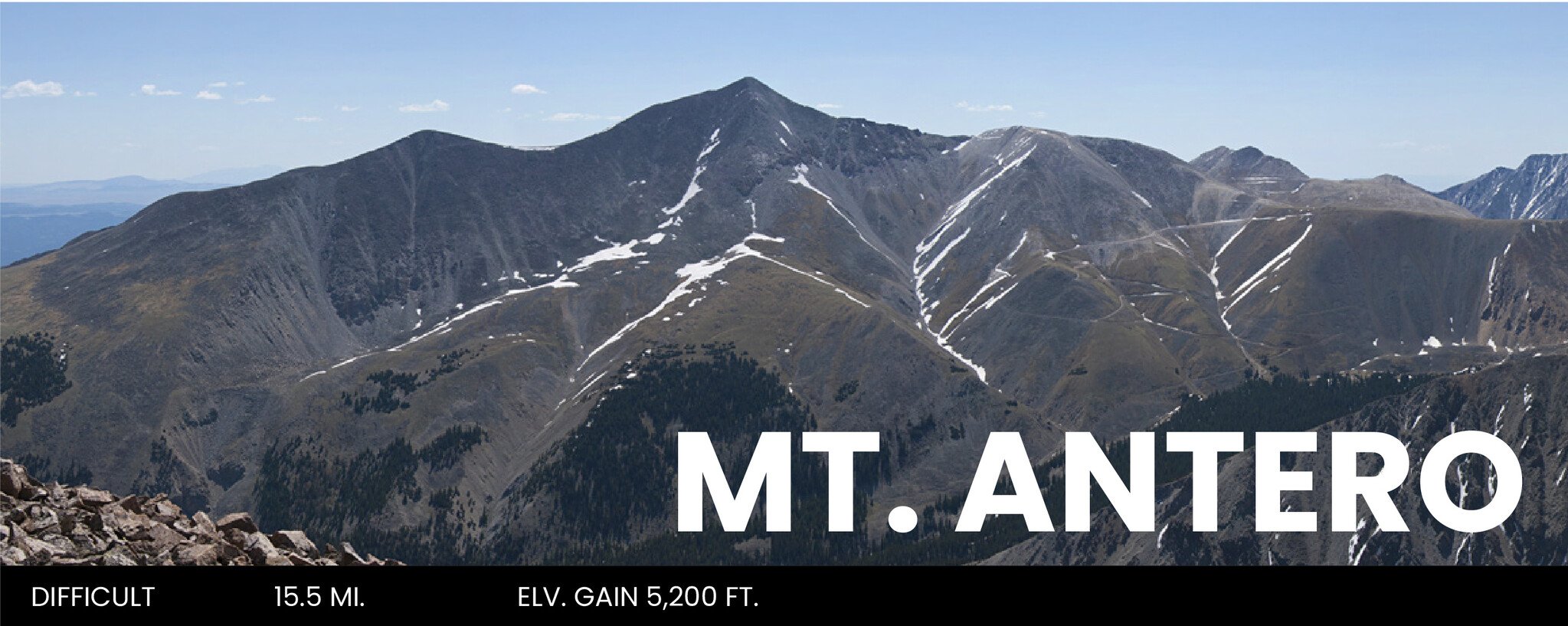
Mount Antero is known for its gemstone deposits and has one of the highest concentrations of aquamarine in the United States. The upper mountain holds many private mining claims, some of which are actively being mined with heavy equipment, making the area a bit of a mess. Via Baldwin Gulch, a rough 4WD road goes all the way to 13,900 feet on Antero, so it's a popular summer destination for more than just hikers. Antero is named in honor of Chief Antero of the Uintah band of the Ute.
DISTANCE: 9.25 miles round trip
ELEVATION: 14,271 ft.
ELEVATION GAIN: 4,500 ft.
RECOMMENDED MAP: Latitude 40 Maps: Summit County
DIRECTIONS: From the junction of U.S. 285 and U.S. 24, south of Buena Vista, drive 5.5 miles south on U.S. 285 and turn right (west) on Chaffee County Road 162 - towards Mt. Princeton. Drive almost 12.5 miles on this road (dirt after 10 miles) to reach the signed Baldwin Gulch Jeep Road on the left (also listed as the 277 Road). If you plan on parking here, there are plenty of pull-offs along the road. This is the lower trailhead. Short, high-clearance 4WD vehicles can drive up the 277 road. Above the river crossing (10,850'), there are dispersed camping spots along the side of the road.
TRAIL ROUTE: Start up the #277 jeep road. Snow usually covers portions of this road to early July. It's fairly steep but can slowly be driven with a high-clearance 4WD vehicle. Hike/drive 3 miles to a road junction. Turn left on the #278 road and cross the stream in Baldwin Creek. Continue nearly 1.5 miles to reach tree line and stay on the road as it begins to switchback up Antero's west slopes. Continue on the road as it zig zags up the west side. Near 12,800', there's a long section of the road That ascends south to reach the ridge crest. Once on the ridge, continue east on 278A. Shortly after leaving the ridge crest, stay left. Walk another 0.4 mile and stay left. Continue up the south side to reach a small saddle.
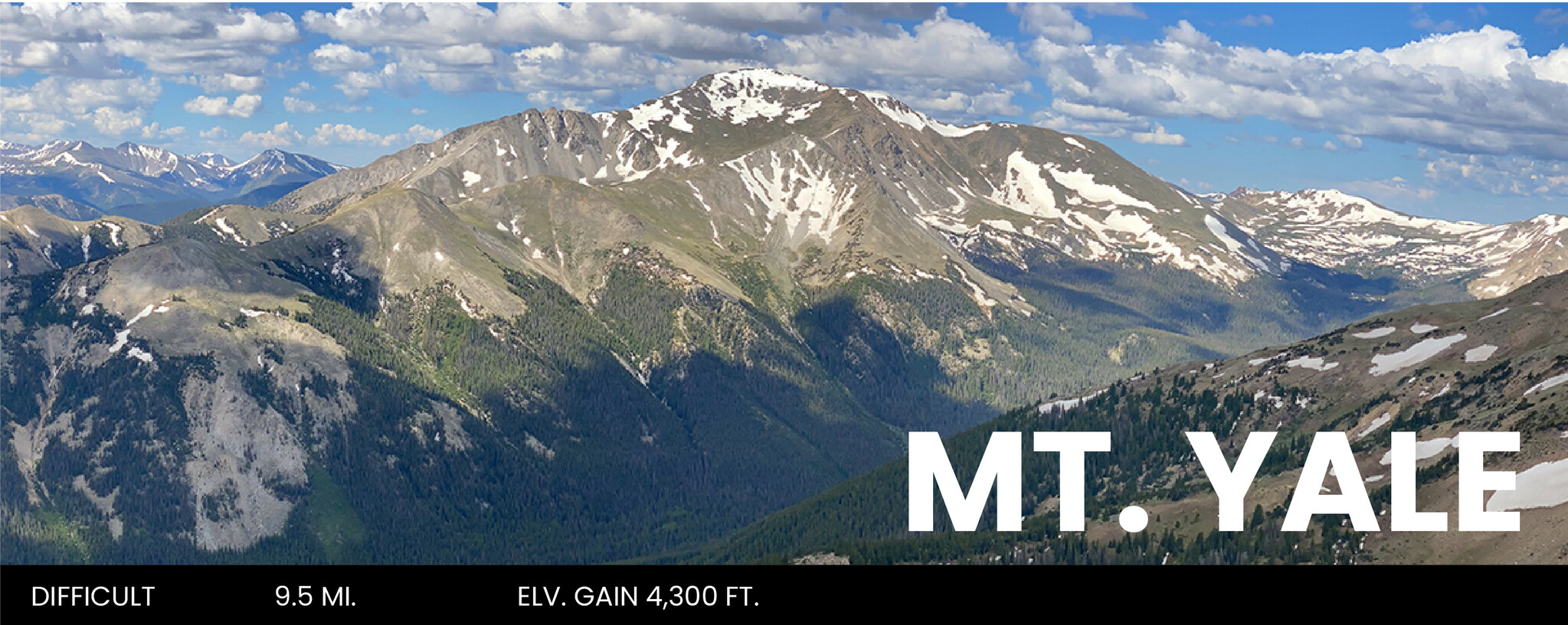
Reaching 14,199 feet, Mount Yale is Colorado’s 21st highest peak. You’ll pass trickling streams and a picturesque meadow as you journey to the summit. At the top, enjoy 360 degree views a variety of mountain peaks, such as Mt. Princeton, Pikes Peak, Mt. Harvard, Mt. Columbia, Huron Peak, Missouri Mountain, Mt. Belford, Mt. Oxford and La Plata Peak. You’ll even get a glimpse of the town of Buena Vista and the Arkansas River Valley.
DISTANCE: 9.5 miles round trip (from the Denny Creek Trailhead)
ELEVATION: 9,900 ft. – 14,199 ft.
ELEVATION GAIN: 4,300 ft.
RECOMMENDED MAP: Latitude 40 Maps: Salida / Buena Vista
DIRECTIONS: From the traffic light in Buena Vista at the intersection of U.S. 24 and Main Street, head west on Main Street/CR 306. Travel 12 miles until you reach the Denny Creek Trailhead and parking lot, located on your right.
TRAIL ROUTE: Hike north on Brown’s Pass Trail. After crossing 2 streams, watch for a small beaver pond on the left. Approximately 200 yards past this pond, look to your right for a path leaving the main trail. Follow this path, heading east. You will cross Delaney Creek and, after another half mile, arrive in an open meadow. Continuing on you will come to a steep section with fallen timber. Make your way up this section. You will come to an open area with Mt. Yale directly in front of you to the east. Follow a row of cairns leading to a 13,900 foot saddle to the left of the summit. After reaching this saddle, hike the rocky ridge southeast to the summit.