- 402 E. Main Street, Buena Vista CO (719.395.8001)
- 78321 US Hwy 40, Winter Park CO (970.281.4148)
- BV 9:00 am - 6:00 pm Every Day
- WP 9:00 am - 6:00 pm Every Day

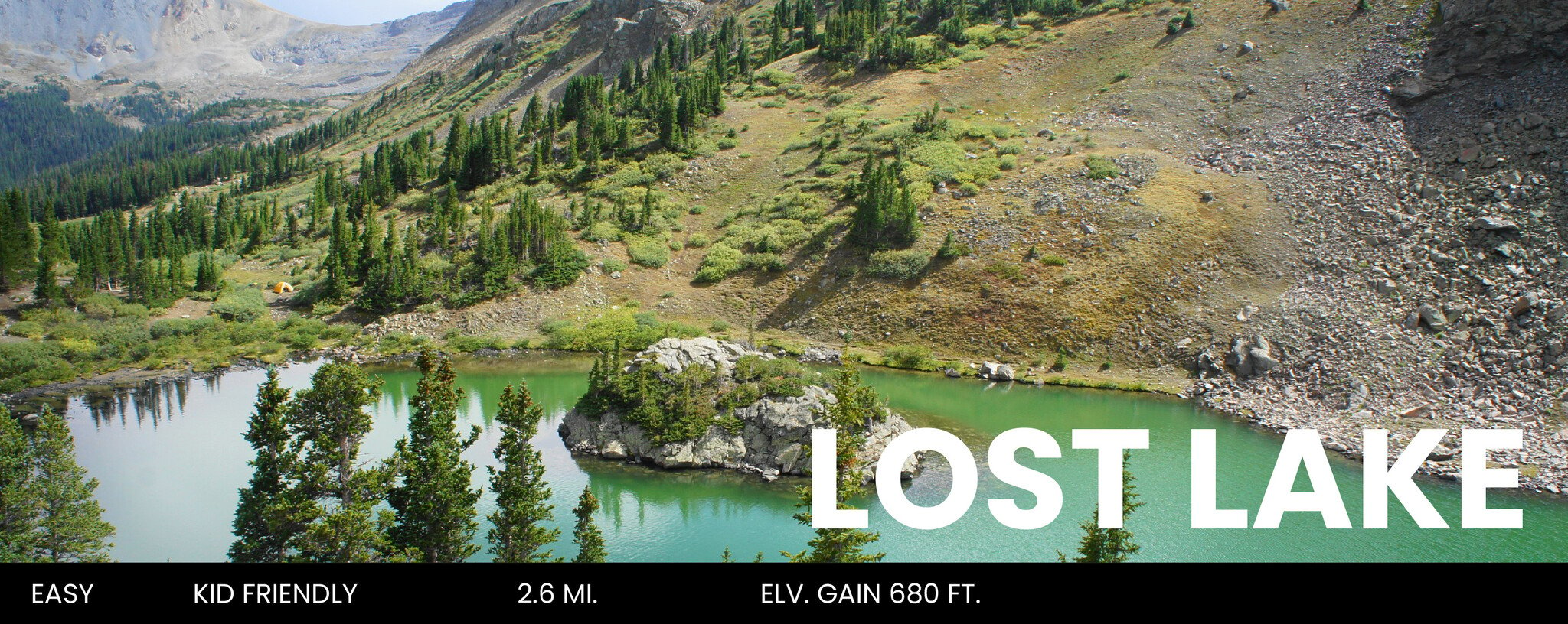
A beginner-friendly hike with beautiful views, located less than 30 minutes from Downtown Buena Vista. This Hike is great for families with young children or for those who aren’t acclimated to Colorado’s high altitude. At an easy pace, this route typically takes about 30-45 minutes one-way. Go in July or August, and you’ll view gorgeous wildflowers in full bloom.
DIFFICULTY: Easy
DISTANCE: 2.6 miles round trip
ELEVATION: 11,195 ft.
ELEVATION GAIN: 680 ft.
RECOMMENDED MAP: Latitude 40 Maps: Salida / Buena Vista
DIRECTIONS: From the stoplight in downtown Buena Vista at the intersection of U.S. 24 and Main Street, head west on Main Street/CR 306 and travel for 18.1 miles. You’ll be going in the same direction as Cottonwood Pass. The trailhead will be on your left, and a small parking section is located on the right side of the road; keep your eyes peeled because the trailhead can be easily missed.
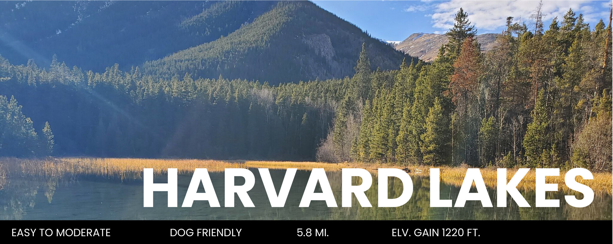
This delightful, dog friendly day hike takes you alongside a beautiful creek that climbs gently through a forest of spruce, pine, and aspen. Upon reaching the first lake, you will have stunning views of nearby alpine peaks. Make sure to peer into the crystal clear water for a chance of spotting brook trout. The second and more expansive lake is a quick jaunt down the path, and serves as a great spot to enjoy a relaxed meal.
DIFFICULTY: Easy to slightly moderate
DISTANCE: 5.8 miles round trip (Elk Creek Trailhead)
ELEVATION: 9,120 ft. – 10,340 ft.
ELEVATION GAIN: 1,220 ft.
RECOMMENDED MAP: Latitude 40 Maps: Salida / Buena Vista
DIRECTIONS: To reach Harvard Lakes via Elk Creek Trail it is not necessary to have 4WD. Head north out of Buena Vista on Highway 24. Roughly three miles north of the stoplight in downtown Buena Vista, you will turn west onto County Road 384. Continue for 1.3 miles and then turn north onto County Road 361. After 1.5 miles turn west onto County Road 368, it is the left hand road where C.R. 361 transitions from gravel to dirt. After 1.2 miles veer left onto 368 A just before the community mailbox. Parking for the trailhead is only a quarter of a mile further up the road (it is a dirt shoulder on the road) and can be recognized by the trailhead marker. There is an open expanse dotted by Ponderosa Pines across from the trailhead.
ROUTE INFO: The trail leads due west from the road for one mile, while gradually climbing in elevation, before reaching a fork. Keeping left at the sign reading Three Elk Trail you will head south and venture into an old logging forest. Once you have crossed Three Elk Creek for the first time you will begin moving in a south westerly direction, and will soon notice an increase in gradient. Continue moving higher into the forest where you will eventually reconnect with the creek. For the remainder of the hike you will parallel the cascading water. After traveling 1.7 miles from the fork you will intersect the Colorado Trail. Head west along its path for a tenth of a mile to behold the first (smaller) lake. From here you continue two tenths of a mile to reach the second lake.
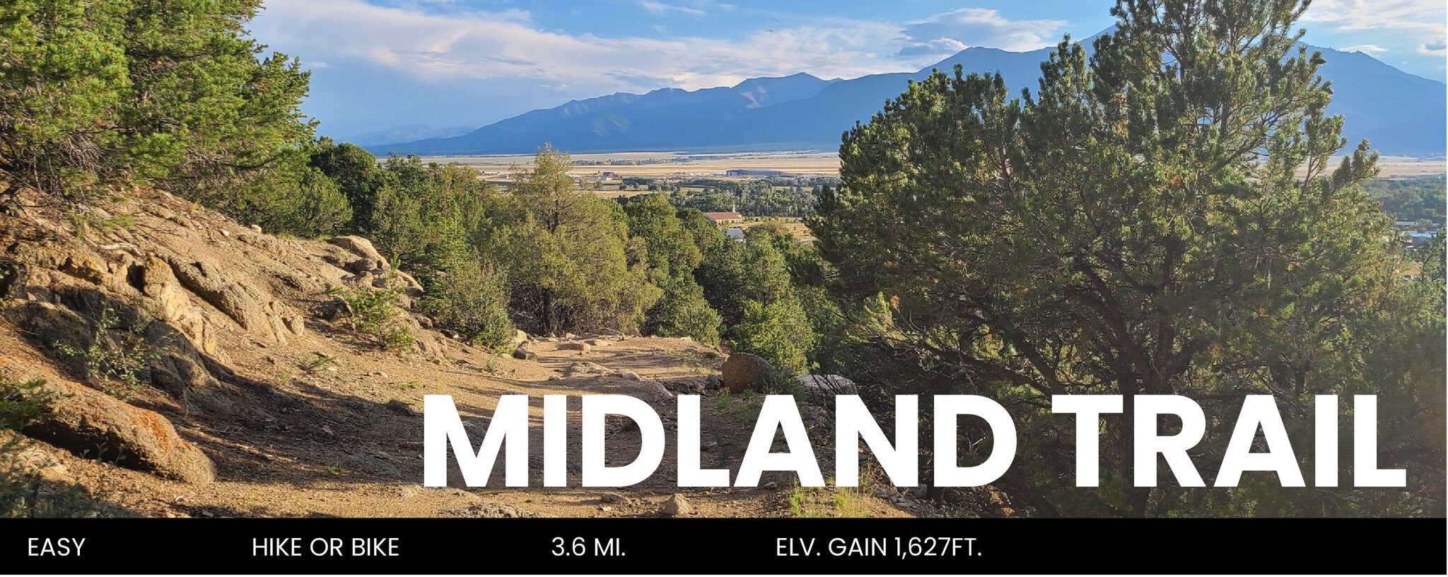
Check out this 3.6 mile out-and-back trail near Buena Vista, Colorado. The Midland Trail offers a pleasant hike that is fairly flat and follows the old Midland Railroad Line. It’s called a bike trail, but it’s perfect for hiking too. There are a few railroad relics along the way and big views of the peaks to the west. The terrain is somewhat desert-like and beautiful. It’s a good hike with children as well.
DIFFICULTY: Easy
DISTANCE: 3.6 miles out-and-back
ELEVATION: 8,470 ft. - 8,644 ft.
ELEVATION GAIN: 1,627 ft.
RECOMMENDED MAP: Latitude 40 Maps: Salida / Buena Vista
DIRECTIONS: From the stoplight in downtown Buena Vista, drive 2.4 miles south on US 24 to the stoplight near Johnson Village. Turn left (east) on US 285 and drive 1.8 miles to CR 304. Turn left (north) on CR 304. The road divides almost immediately, stay to the right going up. The road climbs up for 1.1 miles to a sign that reads “Big Sandy Way”. The trailhead for the Midland Trail is on your right. Park here and begin your hike at the two signs for the Fourmile area and the Midland Trail.
ROUTE INFO: The trail leads due west from the road for one mile, while gradually climbing in elevation, before reaching a fork. Keeping left at the sign reading Three Elk Trail you will head south and venture into an old logging forest. Once you have crossed Three Elk Creek for the first time you will begin moving in a south westerly direction, and will soon notice an increase in gradient. Continue moving higher into the forest where you will eventually reconnect with the creek. For the remainder of the hike you will parallel the cascading water. After traveling 1.7 miles from the fork you will intersect the Colorado Trail. Head west along its path for a tenth of a mile to behold the first (smaller) lake. From here you continue two tenths of a mile to reach the second lake.
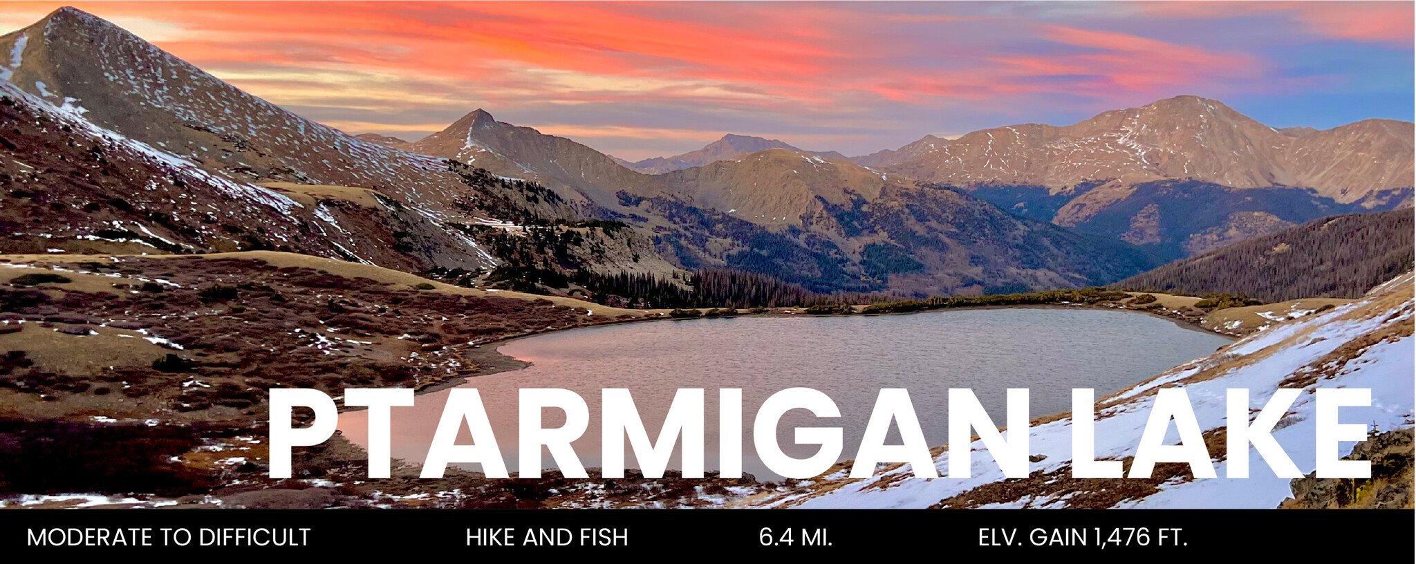
Named for the lovely ptarmigan birds, which live in the area year-round, Ptarmigan Lake sits in a high mountain cirque of big peaks. The trail starts at Cottonwood Pass and climbs through dense pine forests before breaking out into flowery meadows dotted by small ponds. At the lake, look up to see Jones Mountain (12,995 ft.) and the bulky Gladstone Ridge which tops out at 12,661 feet. Looking toward the northern horizons you will see Turner Peak (13,283 ft.) and Mount Yale (14,196 ft.)
The ptarmigan live near treeline year round, feeding on willow buds. They are brown and white colored in summer but change to snow white in winter – the perfect camouflage. You often see them with chicks in the summer and the parent will feign injury to a wing to lure you away. Please treat these gentle birds with respect. Keep your dog on a leash at all times in ptarmigan habitat.
DIFFICULTY: Moderate to Difficult
DISTANCE: 6.4 mi.
ELEVATION GAIN: 1,476 ft.
RECOMMENDED MAP: Latitude 40 Maps: Salida / Buena Vista
DIRECTIONS: From the stoplight in downtown Buena Vista, drive west on West Main Street, which turns into CR 306. Follow CR 306 just 14.5 miles to the Ptarmigan Lake Trailhead. Turn left, drive 0.2 mile into the trailhead and park. The trail starts here.
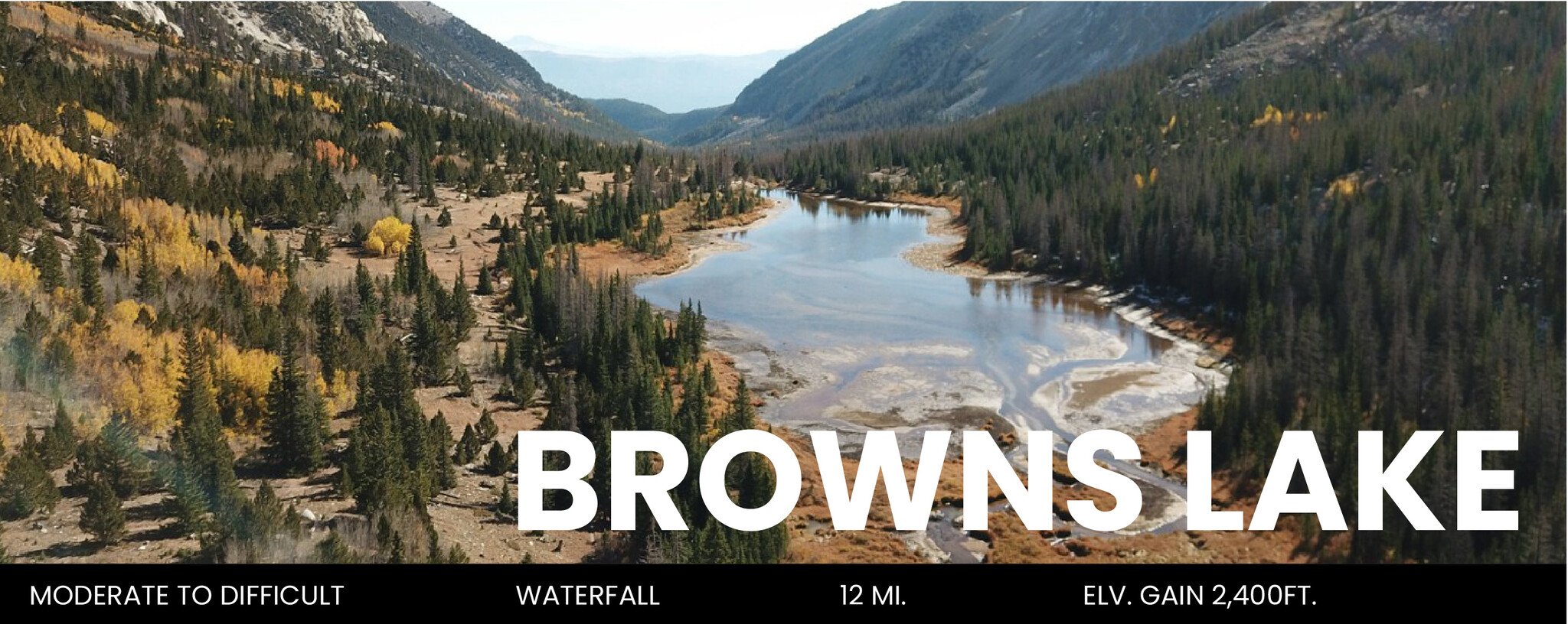
A stunning alpine lake with incredible views surrounding the water. The Browns Creek Trail will lead you through a breathtaking meadow, and you’ll see and hear the trickling creek for much of your hike. After about 2.5 miles, look for a sign that indicates a waterfall and veer to your left to view the gorgeous falls. If you want to make this hike easier, stop at the waterfall to take a break or eat lunch, and then head back the way you came, making it a 5 mile round trip. Continue another 3.5 miles to the lake if you want a tougher hike or if you want to stop for a night of camping. Browns Lake is a great place to base camp before peaking Mount Antero.
DIFFICULTY: Moderate to Difficult
LENGTH: 12 miles round-trip (5 miles round-trip if you stop at waterfall)
STARTING ELEVATION: 8,900 ft.
ELEVATION GAIN: 2,400 ft.
RECOMMENDED MAP: Latitude 40 Maps: Salida / Buena Vista
DIRECTIONS: From downtown Buena Vista, travel east on US Highway 24 (heading towards Salida). After about 2.4 miles, US-24 East will turn into US-285 South. Continue about 8.8 miles until you reach County Road 270. Turn right onto County Road 270 and continue for about 1.5 miles, and then continue straight onto County Road 272. After about 2 miles, turn left to stay onto County Road 272. Keep following County Road 272 until you reach the Browns Creek trailhead. Total driving time from downtown Buena Vista should be about 30 minutes.